Google is taking Street View down—into the Grand Canyon, that is. “On its first official outing, the Street View team is using the Trekker—a wearable backpack with a camera system on top—to traverse the Grand Canyon and capture 360-degree images of one of the most breathtaking natural landscapes on the planet,” read an Oct. 24 posting on Google’s Official Blog. The Trekker automatically records high-quality images as the operator walks. Google’s initial foray into the canyon will take place around the South Rim of Grand Canyon National Park, which includes some famous paths such as the Bright Angel Trail. Google promised to make the images live (at some point) on Google Maps. “The narrow ridges and steep, exposed trails of the Grand Canyon provide the perfect terrain for our newest camera system,” the blog added. Google has been rapidly updating Google Maps of late, perhaps in a bid to strengthen the platform in the face of new competition from Apple. Many of those updates involve Street View, which includes new coverage from a range of countries including the United States, Taiwan, Denmark, Norway, Canada and Thailand. “Today we’re making our Street View coverage more comprehensive than ever before by launching our biggest ever update,” read an Oct. 11 note on Google’s Lat Long blog, “doubling our number of special collections and updating over 250,000 miles of roads around the world.” Google’s employees have spent years assembling the company’s extensive mapping database and offering it to users via the cloud. While that places the search-engine giant in an enviable position with regard to digital cartography, other companies are doing their best to catch up: Nokia has made significant investments in its own digital mapping abilities, including the $8 billion purchase of Navteq and a steady flood of GPS data from FedEx and UPS. Apple is also trying to create a robust digital mapping hub with its iOS 6 Maps app. In order to do so, Apple reportedly acquired a number of independent mapping firms including C3 Technologies, a builder of 3D maps, and Canadian mapping firm Poly9. However, iOS 6 Maps attracted a fair amount of criticism soon after the mobile operating system’s launch, with users complaining of inaccurate maps and directions. Image: Google
 Google Street View Heads into the Grand Canyon
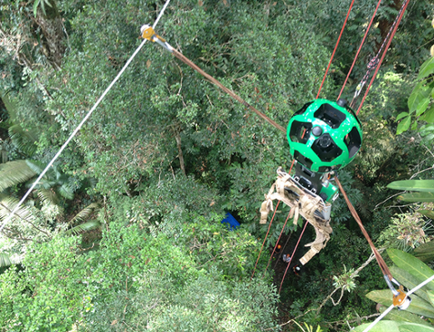
Google is taking Street View down—into the Grand Canyon, that is. “On its first official outing, the Street View team is using the Trekker—a wearable backpack with a camera system on top—to traverse the Grand Canyon and capture 360-degree images of one of the most breathtaking natural landscapes on the planet,” read an Oct. 24 posting on Google’s Official Blog. The Trekker automatically records high-quality images as the operator walks. Google’s initial foray into the canyon will take place around the South Rim of Grand Canyon National Park, which includes some famous paths such as the Bright Angel Trail. Google promised to make the images live (at some point) on Google Maps. “The narrow ridges and steep, exposed trails of the Grand Canyon provide the perfect terrain for our newest camera system,” the blog added. Google has been rapidly updating Google Maps of late, perhaps in a bid to strengthen the platform in the face of new competition from Apple. Many of those updates involve Street View, which includes new coverage from a range of countries including the United States, Taiwan, Denmark, Norway, Canada and Thailand. “Today we’re making our Street View coverage more comprehensive than ever before by launching our biggest ever update,” read an Oct. 11 note on Google’s Lat Long blog, “doubling our number of special collections and updating over 250,000 miles of roads around the world.” Google’s employees have spent years assembling the company’s extensive mapping database and offering it to users via the cloud. While that places the search-engine giant in an enviable position with regard to digital cartography, other companies are doing their best to catch up: Nokia has made significant investments in its own digital mapping abilities, including the $8 billion purchase of Navteq and a steady flood of GPS data from FedEx and UPS. Apple is also trying to create a robust digital mapping hub with its iOS 6 Maps app. In order to do so, Apple reportedly acquired a number of independent mapping firms including C3 Technologies, a builder of 3D maps, and Canadian mapping firm Poly9. However, iOS 6 Maps attracted a fair amount of criticism soon after the mobile operating system’s launch, with users complaining of inaccurate maps and directions. Image: Google